| Current status | 2022 |  |
| Short term status | 2018 - 2022 |  |
| Long term status | 2006 - 2022 |  |
Click on the charts below in order to see the full resolution versions.
In the past 30 years, there have been five national surveys estimating the extent of forest cover in Ireland: the Forest Inventory Planning System 1998 (FIPS), and the National Forest Inventory (NFI) conducted in 2004-2006, 2009-2012, 2015-2017 and 2020-2022. FIPS, a remote-sensed inventory of forest cover produced from aerial photographs and satellite imagery, estimated the national native forest cover of mixed and broadleaf woodland not dominated by beech (a non-native tree species) to be 82,321 ha or 1.2% of the state. The NFI involved a detailed survey of permanent forest sample plots (500 m2) selected randomly across a 2 x 2 km grid (17,423 points nationally), 1,742 plots were surveyed 2004-2006 (Anon., 2007), 1,827 surveyed 2009-2012 (Anon., 2013), 1,932 surveyed 2015-2017 (Anon. 2017) and 2,020 surveyed 2020-2022.
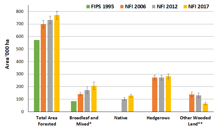
The most recent NFI estimates that the total area under native broadleaf and mixed forest to be 206,540 ha, an increase of 32,220 ha (19%) from the NFI estimate in 2012 and an increase of 124,220 ha (151%) on the FIPS estimate in 1995. However, these estimates include stands of trees of both native (>80% native tree species) and mixed (20-80% native tree species) status. The most recent estimate of area of native stands is 128,130 ha, up by 27,620 ha (27%) on the 2012 estimate, but not reported in the previous surveys (FIPS 1995 and NFI 2006).
The most recent NFI estimates that the total area under native broadleaf and mixed forest to be 229,390 ha, an increase of 22,850 ha (11%) from the NFI estimate in 2017 and an increase of 56,070 ha (32%) on the FIPS estimate in 2012. However, these estimates include stands of trees of both native (>80% native tree species) and mixed (20-80% native tree species) status. The most recent estimate of area of native stands is 147,330 ha, up by 19,200 ha (15%) on the 2017 estimate, and 46,820 ha (47) on the 2012 estimate.
The NFI also estimates the area of hedgerow (linear features < 20 m with tree and/or shrubs present). Hedgerows area has decreased when compared with both the 2012 and 2017 estimates, however the decreases do lie with the margin of error of the estimates.
In NFI 2006 and NFI 2012, the area of scrub (areas dominated by woody vegetation 0.5 – 5 m in height) habitats was estimated, but in NFI 2017 this land-use was reclassified under a pre-existing category ‘Other Wooded Habitats’. For comparability, the area of ‘Scrub’ and ‘Other Woodland’ in previous surveys were combined to compare with NFI 2017 ‘Other Wooded Habitats’. These transitional habitats have declined by 22,500 ha (50%) since 2012.
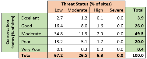
In terms of the conservation status of our native woodlands, the National Survey of Native Woodlands funded by the National Parks and Wildlife Service and the Forest Service, surveyed 1,217 woodland sites across all 26 counties from 2003-2007 (Perrin et al., 2008). A range of criteria relating to the site area, occurrence of rare species, structural diversity and regeneration status were used to evaluate the conservation status of each site, and the impact of invasive species, non-native tree species and grazing were used to assign a threat status to each site. Overall, 29.9% of sites were of Excellent or Good conservation status, whereas 93.7% of site had a Low or Moderate threat status.
At present, the current and short-term status of this indicator is intermediate as although planting native (>80% native trees) and mixed (20-80% non-native) woodlands has increased, the net impact on biodiversity when accounting for losses to existing, but highly fragmented, old (continuously wooded since 1830-44 Ordinance Surveys) or ancient woodlands (continuously wooded since 1660) is unclear (Iremonger et al., 2006; Perrin et al., 2010).
More information on the National Forest Inventory can be found here:
http://www.agriculture.gov.ie/nfi/
More information on the National Survey of Native Woodlands can be found here:
http://www.npws.ie/research-projects/woodlands
References
Anonymous (2007) National Forest Inventory. Forest Service, Department of Agriculture, Fisheries and Food, Johnstown Castle Estate, Co. Wexford.
Anonymous (2013) The Second National Forest Inventory. Forest Service, Department of Agriculture, Food and the Marine, Johnstown Castle Estate, Co. Wexford.
Anonymous (2017) Ireland’s National Forest Inventory 2017 – Main Findings. Forest Service, Department of Agriculture, Food and the Marine, Johnstown Castle Estate, Co. Wexford.
Iremonger, S., O'Halloran, J., Kelly, D.L., Wilson, M.W., Smith, G.F., Gittings, T., Giller, P.S., Mitchell, F.J.G., Oxbrough, A., Coote, L., French, L., O'Donoghue, S., McKee, A.-M., Pithon, J., O'Sullivan, A., Neville, P., O'Donnell, V., Cummins, V., Kelly, T.C. and Dowding P. (2006). Biodiversity in Irish Plantation Forests. Environmental Protection Agency and COFORD, Dublin. 82pp.
Perrin, P.M, Martin, J.R., Barron, S.J., O’Neill, F.H., McNutt, K.E. and Delaney, A. (2008) National Survey of Native Woodlands 2003-2008. Unpublished report submitted to National Parks and Wildlife Service, Dublin.
Perrin, P.M., Daly, O.H. (2010) A provisional inventory of ancient and long-established woodland in Ireland. Irish Wildlife Manuals, No. 46. National Parks and Wildlife Service, Department of Environment, Heritage and Local Government, Dublin.


